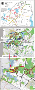
Maps showing the trails currently open to bikes, the proposed expansion, and the compromise presented on June 1 (the area outlined in yellow would not be open to bikes). Click to enlarge.
After getting pushback on a number of proposed changes to conservation trail use regulations, the Conservation Commission revised some of its recommendations and postponed a vote until at least June 22.
In recent weeks, dozens of residents submitted comments on the proposals and attended a May 18 public forum, while more than 70 people attended the June 1 ConCom meeting via Zoom. Many were against allowing some expansions in trail use as outlined in the panel’s April 25 draft regulations. The discussion focused on four aspects of the proposed revisions:
- A leash requirement for more trails, particularly those around Flint’s Pond
- Opening more of Mt. Misery’s trails to bicyclists
- A requirement that dogs must be leashed when another trail user approaches
- A requirement that five or more bikers must get a group use permit in advance
ConCom chair Susan Hall Mygatt presented suggestions for adjusting the proposed rules in each case. She agreed it would be “more realistic” to require dogs to be at the owners side and under voice control rather than require the owners to put them on leashes every time they encounter another walker.
Under the current rules, groups of 10 or more individuals are required to obtain a Group Use Permit ahead of time to use the trails. Section 9 of the proposed regulations makes that more specific, requiring a permit for 10 or more people (pedestrians), five or more bikers, and five or more horseback riders. The amended suggestion includes a provision that rive or more “unrelated” bikers or horseback riders will need a permit, though some commenters at the June 1 meeting suggested tightening the biker group limit even further. ConCom members agreed that there should be some “wiggle room” for groups of children on a school outing.
There had also been disagreement about an earlier proposal to open up more trails to bikers. Mygatt and Conservation Director Michelle Grzenda presented a compromise whereby some of the trails on the northern side of the popular Mt. Misery area would remain closed to bikers.
“The erosion and wear and tear on Mt. Misery has increased significantly,” said resident Elizabeth Orgel.
However, resident Margaret Olson argued for more trail connectivity to help people get around town by bike as much as possible. “Reserving some areas for contemplative use makes sense but I’d like to work over time to open more of the trails to bikes,” she said. Another resident wondered whether the prohibition on motorized vehicles applied to e-bikes, which are growing in popularity.
Requiring dogs to be leashed around Flint’s Pond was proposed to protect the town water supply from contamination by dog feces, though there was some debate as to whether town water quality is currently suffering from the lack of such restraints. In recent years and especially since the Covid-19 endemic, more dogs and swimmers have been seen in the pond despite signs prohibiting anyone from getting closer than 20 feet from the water, as per state DEP regulations.
“We’ve just gotten lucky that the DEP hasn’t forced us to put a fence around all of it already,” said Water Commissioner Michelle Barnes, who is also chair of the Lincoln Land Conservation Trust/Rural Land Foundation.
“I think a lot of us question their effectiveness,” Barnes said about the signs listing prohibited activities. “Also, I think historically we haven’t had strong enforcement from the Police Department.”
Some years ago, there was a ranger program funded jointly by the Conservation and Water Departments, and that as a result, the DEP did not impose stricter Flint’s Pond and watershed water protection measures on the town. At an August 2020 Water Commission meeting, Barnes said she had discussed stepped-up enforcement and possible installation of video cameras to tackle the problem, though it’s unclear if any new measures were subsequently put in place. She also acknowledged that it’s difficult for police to catch people or dogs while they’re in the water.
The Conservation Commission will resume its discussion of trail regulations on Wednesday, June 22 at 8 p.m.
There has been much talk, over time, about trials and paths creating “connectivity” for those who want to use bikes as an alternative to cars to move about town.
Yet, it is not clear what that means.
What trails/path could/should be used to do so?
Perhaps such a map should generated for discussion and for Con. Comm. consideration prior to final decisions about expanding trails available to bikes.
Great idea! I clear and explicit map for trail use by bikes should be created and made widely available.
Trail connectivity is a laudable goal. A discussion needs to be accompanied by a proposed plan for which trails to connect and guidelines for (non-electric) bikes to follow when using trails. Without such a proposed plan and discussion, our trails will be used by all and bikes may not be appropriate for some areas. More clearly marked bicycle paths along roads and highways throughout Lincoln also could provide greater connectivity throughout town and send a message that Lincoln values this means of transportation. We shouldn’t rely on our conservation trails to provide an alternative for which town roads and byways also should be used.