By Alice Waugh
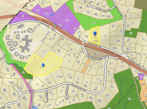
A wireless technology company is seeking to rezone a piece of residential property on Emerson Road to allow construction of a new cell tower that would replace two existing towers on Mary’s Way. The Planning Board will hold a public hearing on the proposal on Tuesday, Feb. 25 at 7:15 p.m.
Crown Castle International Corp. currently operates two cell towers at 9 Mary’s Way adjacent to the Oriole Landing development and The Commons in Lincoln. The company in turn leases space on the tower to wireless communications companies including AT&T and Sprint. According to a January 21 letter to town officials, the lease on the Mary’s Way parcel is expiring and the company has been unable to negotiate an extension, so “it is necessary to install a relocation tower to address the continuation of wireless service on the networks of some of the leading providers in the town of Lincoln.”
Crown Castle is seeking to add the parcel at 6 Emerson Rd. owned by the Sandra Demirjian Trust and Daniel Cellucci to the town’s Wireless Communications Facility Overlay District, which currently includes 11 parcels on Route 2, Mill Street, Lincoln Road, Lewis Street, Bedford Road, and Sandy Pond Road. (The addresses of the parcels and accompanying overlay district provisions are listed starting on page 43 of the town’s Zoning By-Law.)
The wireless overlay district is one of several zoning districts consisting of noncontiguous parcels that were created to impose special provisions (for example, more restrictions or additional permitted uses) in addition to the existing zoning rules for those properties. The others are the Wetlands and Watershed Protection District, the Flood Plain District, the North Lincoln Overlay District, the South Lincoln Overlay District, and the Solar Photovoltaic Facilities Overlay District.
The property at 9 Mary’s Way is owned by the David Miller Trust and the John Yagjian Trust, c/o David Segal of 11 Mary’s Way. None of the owners listed for the two properties could be reached for comment.
If the cell towers on Mary’s Way were to be abandoned, the facility owners are required to remove their structures and restore the site to its former condition within one year of the cessation of use.

Leave a Reply