 (Editor’s note: the Wikipedia links in this article were added by the editor for explanatory purposes and were not provided by the author or the Lincoln Historical Society.)
By Sara Mattes
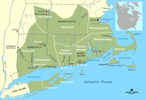
About 1,000 years ago, the inhabitants of what would become Lincoln were the Algonkin people. The paths created for trade between tribes, in some instances, became the routes of roads in use today. But contact with Europeans in the 17th century brought diseases that killed a significant portion these original inhabitants.
A settlement that survived in the Concord area, led by Squaw Sachem and sagamore Tahattawan, was known as Musketaquid, their name for the Concord-Sudbury River. (Sachems and sagamores were paramount chiefs among the Algonkins and other Native American tribes of the northeast.) In 1635, the Great and General Court granted a six-mile square tract at Musketaquid to English settlers, to be called Concord. The following year, Squaw Sachem, Tahattawan, and others consented to the sale of this land to the English settlers.
Some of the original Massachusetts tribe remained on the land, but by the end of King Philip’s War in 1678, the few remaining original habitants had been driven from their homes or had died from disease brought by the Europeans. By the time Lincoln was formed in 1754, all of its portion of Musketaquid was owned and settled by Europeans.
None of this tells of the conditions of the relationships between the First Peoples and the Europeans in Lincoln, and especially under what terms the sale of land was made. That is a topic for another day.
* * *
This article is indebted to A Rich Harvest by Lincoln’s town historian, Jack MacLean. A Rich Harvest is available at the Lincoln Public Library and for purchase from the Lincoln Historical Society. For a more in-depth study, see The First People of the Northeast by Lincoln authors Esther K. Braun and David P. Braun, also available at the Lincoln Public Library.
“Lincoln’s History” is an occasional column by members of the Lincoln Historical Society.

The map and caption are misleading. The original map on Wikipedia specifically identifies it as showing southern New England tribes, while the peoples who spoke Algonquin/Algonkin dialects extended well beyond that area, including much of eastern Canada. Squaw Sachem lived in the Mistick/Mystic area and was the leader of the Pawtucket Confederation, which included Musketaquid/Concord (where Tahattawan was the local leader). On this southern New England map, the Pawtucket Confederation is not shown, but it would have been north of the Massachusett tribe. While not so represented on this map, along the coast think of the Charles River as a divide, with the Massachusett from Shawmut/Boston south and the Pawtucket from Mishawam /Charlestown north. The Pawtucket tribe has been attributed as speaking the Western Abenacki dialect of the Algonquin language, which would culturally associate its peoples more with northern New England tribes. These tribal divides also represent conditions at the time of contact and not necessarily earlier periods.
Jack MacLean